- Seismics
- Coring Equipment
- Sediment physics
- Sediment chemistry
- Process rates
- Microbiology
- Molecular biology
- Water column
Principles of shallow seismic mapping![]()
Seismic instruments![]()
Interpretation of acoustical data in METROL![]()
The structure and lamination of the seabed and the occurrence of free gas are analyzed by seismic profiling in the METROL study areas. The acoustic equipment and the profiling strategies differ among the cruises and the participating geophysical partners. The following summary is therefore arranged according to study areas and, thus, research vessels.
Principles of shallow seismic mapping
High frequency reflection seismic measurements at sea are based on the frequent transmission of sound pulses while the survey vessel is sailing. By recording the sound energy reflected by the seabed and underlying strata, the depth of the seabed and sub-bottom strata can be determined. The seismic profiles comprise longer transects through relevant areas as well as grid profiles with the aim of mapping local areas comprising seeps or other significant structures.![]()
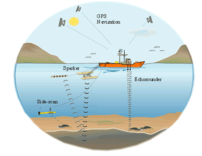 |
An echosounder transmits high frequency sound waves in the range of 10-200 kHz. Almost all energy in this range is reflected by the seabed, which enables a precise measurement of the water depth with an accuracy of a few centimetres. Accurate positioning is crucial for seismic mapping. The differential global positioning systems (DGPS) is a radio based navigation system that can yield measurements good to less than five meters.
The seismic data obtained with the above described methods give an acoustic impression of the seabed sediments and sediment strata below. This impression is visualized by acoustic imagery, in which the penetration of the sound waves into the seabed and their sub-bottom reflections in the different strata is expressed as a vertical pattern of shading. Various known types of deposition can be recognised by interpretation of the acoustic imagery: Sound waves penetrate relatively easily into fine grained sediments as mud, silt, and clay, while penetration depths are very limited in sand, gravel and glacial till. Gas, which can be formed by decomposition of organic matter and frequently occurs in muddy seabed sediments, imposes a particular acoustic problem. Where mud deposits have reached thicknesses in excess of ca 2 m, gas has usually built up in sufficient amounts to absorb all acoustic energy. Consequently, no information is available from the underlying sedimentary strata.
back to top